

DEM, DSM & DTM: Digital Elevation Model – Why It’s Important
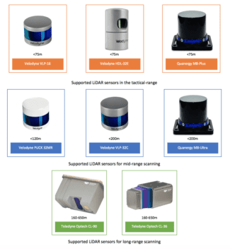
Digital Elevation Model vs Digital Surface Model vs Digital Terrain Model Geodetics’ Geo-MMS LiDAR and Point&Pixel products are used to generate highly accurate and dense LiDAR point clouds in the standardized LAS file format. With capabilities of up to four returns per beam and a data rate up to 1000k (points/second) per return – depending …
DEM, DSM & DTM: Digital Elevation Model – Why It’s Important Read More »