Intech Survey


Surveying & Mapping Service

Membuka Kekuatan Survei LiDAR: Merevolusi Pengumpulan dan Analisis Data

whatsapp, whatsapp icon, whatsapp logo-6860919.jpg   Hubungi Kami


Jasa Survey Akurat & Tepat
Dengan Kualitas Terbaik

UAV Lidar Survey

land Survey

Survey Topografi

Pemetaan Udara

Batimetri Survey

Lorem ipsum dolor sit amet, consectetur adipiscing elit. Ut elit tellus, luctus nec ullamcorper mattis, pulvinar dapibus leo.

What is GIS and is it the same as Geospatial data?

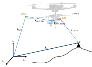
A Geographic Information System (GIS) is a computer system and/or software built to manage and display all kinds of spatial or geographical data.

Geospatial data is the geographic information that identifies the location (where things are) and details of features on earth (descriptive information including measurements). Things such as oceans, trees, roof tops, road signage and so on can all be digitised, so the data can be analyzed and turned into maps, models and useful information for multiple industries.

Leave a Comment

Your email address will not be published. Required fields are marked *

× Whatsapp