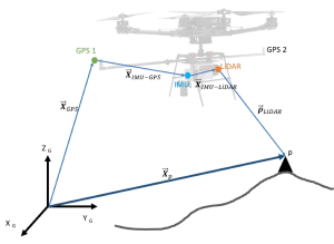


Geospatial (or ‘spatial’) data refers to any data containing information about a specific location on the Earth’s surface. Where we live, places we travel, the position of road signs, tracking the cat (or dog…) – the list of spatial information we use everyday is endless. But how do we ‘use’ it?
Geospatial data is available in a variety of formats, such as ‘maps’, a common user-case for imagery and location data, but not the only, or even necessarily the most useful, format.
By analyzing spatial data we can learn more about why certain ‘location’ relationships exist. Decisions can then be made based on this knowledge, such as where to build, taking into account risks such as flood, trees and more, or why does a particular store attract more people than another. For a long time, Geospatial data has been leveraged by experts to understand human behaviour, and Getmapping want to make it easier for all levels of expertise to access and leverage the power of Spatial data.